Chasing a world record for driving through the lower 48
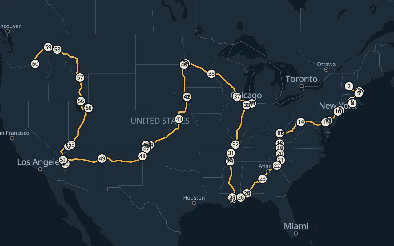
The map shows a route that could give a team a shot at the record for driving through all 48 contiguous states. By my estimate, it cuts 7 hours and 10 minutes of driving compared with the route I pieced together from a 2019 team's journal.
Rebuilding the 2019 run
Road & Track reported a time of 86 hours and 19 minutes in 2021, the fastest I found. I couldn't find that team's full route, so I went back to a crew that logged 94 hours and 25 minutes in their 2019 travel journal. I connected 34 places from the journal by road and filled in likely crossings between entries.
I estimated the driving time for each stretch of road using posted speed limits where available. Then I added up those times for both routes. That's the road model behind the estimates below.
The route I pieced together came out about 4% longer than the team's reported 6,619 miles. Its estimated driving time was 15 hours and 9 minutes longer than the time they reported. Some of that difference may come from the roads I filled in and the speeds used to estimate the drive.
-
2019 reconstruction109 h 34 min estimated driving
-
Proposed route102 h 24 min estimated driving
- Both routes
The new route cuts 7 hours and 10 minutes from the driving estimate even though it covers only about 39 fewer miles. Its estimate is still higher than the 86 hours and 19 minutes the 2021 team reported.
Where you cross changes the trip
Even with the states in the same order, you can get a faster route by crossing their borders at different places. I kept the 2019 team's state order and looked for faster routes through those states. Then I tried changing the order too.
Oregon was the last state on the 2019 team's list. The team wrote that the switchbacks south of Anatone slowed them down. A state counts as soon as you drive across the line, so any road into Oregon would do. My route enters on US 730 along the Columbia River.
2019 approach on SR 129
New approach on US 730
The fastest route I found with the 2019 state order came within 3 minutes of my best result. You can visit the same states in the same order and still end up with a very different drive.
What happens on the road?
Could a team beat 86 hours and 19 minutes on this route? The pace Road & Track reported suggests the 2021 crew went over the limit on some stretches. An actual run would show how the route holds up through traffic, fuel stops, and driver changes.
The 2021 team of 3 took turns driving, navigating, and resting. For a run like this I'd also time the drive through big cities to miss rush hour and scout easy exits for fuel and driver changes. Have a navigator log each crossing so you can see where the plan held up.
Follow the state crossings
The 6,862-mile route starts in Vermont and ends in Oregon. It crosses 59 state lines and stays within the U.S.
State entries in order
- 1Vermont
- 2New Hampshire
- 3Maine
- 4New Hampshire again
- 5Massachusetts
- 6Connecticut
- 7Rhode Island
- 8Connecticut again
- 9New York
- 10New Jersey
- 11Pennsylvania
- 12Delaware
- 13Maryland
- 14West Virginia
- 15Ohio
- 16West Virginia again
- 17Kentucky
- 18Virginia
- 19Tennessee
- 20North Carolina
- 21South Carolina
- 22Georgia
- 23Alabama
- 24Florida
- 25Alabama again
- 26Mississippi
- 27Louisiana
- 28Mississippi again
- 29Tennessee again
- 30Arkansas
- 31Missouri
- 32Illinois
- 33Indiana
- 34Michigan
- 35Indiana again
- 36Illinois again
- 37Wisconsin
- 38Minnesota
- 39North Dakota
- 40South Dakota
- 41Iowa
- 42Nebraska
- 43Kansas
- 44Oklahoma
- 45Colorado
- 46Oklahoma again
- 47Texas
- 48New Mexico
- 49Arizona
- 50California
- 51Nevada
- 52Arizona again
- 53Utah
- 54Wyoming
- 55Utah again
- 56Idaho
- 57Montana
- 58Idaho again
- 59Washington
- 60Oregon
Download the route and plan your run
GPX works in most navigation apps, such as OsmAnd and Organic Maps. KML opens in Google Earth. The files carry the whole route and a waypoint just inside each state.
The directions come in 16 overlapping parts. Google Maps and Apple Maps calculate their own paths between the points. Use the GPX track to see the modeled route.
The start and finish pins sit on the road. Use the South Main Street lot in White River Junction to get ready. After the Oregon line, you can continue on US 730 to Hat Rock State Park. The park requires a day-use parking permit. White River Junction parking. Hat Rock State Park.
Putting together a team for the lower 48 record? Tell me about your plan.
Follow the 3 waypoints on the Florida loop as pass-through points.
- Part 1 Vermont to MassachusettsGoogle MapsApple Maps
- Part 2 Massachusetts to New YorkGoogle MapsApple Maps
- Part 3 New York to MarylandGoogle MapsApple Maps
- Part 4 Maryland to KentuckyGoogle MapsApple Maps
- Part 5 Kentucky to South CarolinaGoogle MapsApple Maps
- Part 6 South Carolina to FloridaGoogle MapsApple Maps
- Part 7 Florida to Alabama (again)Google MapsApple Maps
- Part 8 Alabama (again) to Tennessee (again)Google MapsApple Maps
- Part 9 Tennessee (again) to IndianaGoogle MapsApple Maps
- Part 10 Indiana to WisconsinGoogle MapsApple Maps
- Part 11 Wisconsin to IowaGoogle MapsApple Maps
- Part 12 Iowa to ColoradoGoogle MapsApple Maps
- Part 13 Colorado to ArizonaGoogle MapsApple Maps
- Part 14 Arizona to UtahGoogle MapsApple Maps
- Part 15 Utah to MontanaGoogle MapsApple Maps
- Part 16 Montana to OregonGoogle MapsApple Maps
Route files carry the OpenStreetMap attribution and ODbL notice.