Chasing the 24-hour world record for most countries visited by land
Could you visit 19 European countries by land in 24 hours? The record is 18. The quickest route I found through 18 takes 24 h 38 min in the model. From there I worked out what it would take to reach a 19th and how much farther you could get with another day.
A different route through the same 18
Phil Billingham's team started in Poland in 2014 and stopped for photos in every country on their way to the Netherlands. They reached 18 countries by land within 24 hours, setting RecordSetter's world record.
I started with Billingham's published country order. The road model puts that trip at 24 h 54 min. Starting in the Netherlands and rearranging the same 18 countries brings it down to 24 h 38 min, a saving of 16 minutes on the same model.
-
2014 reconstruction24 h 54 min estimated trip timePoland to the Netherlands
-
Proposed route24 h 38 min estimated trip timeNetherlands to Poland
- Both routes
To see how the estimates held up on the road, I compared the reported times through 17 countries on 2 earlier runs with estimates for those country orders. The teams took about 3% less time than the model estimated, on average. Billingham's 2014 run and Hepworth's 2012 run.
If that difference held for the new 18-country route, it would take 23 h 49 min, with about 11 minutes to spare. I budgeted 2 minutes per visit to stand in the country and document it, as RecordSetter requires.
Billingham credited quiet roads and clear border crossings. A crew can scout legal places to pull over before it sets out. Once the clock starts, even a short border queue could use up that margin. Stroke Association report on the run.
Netherlands to Poland takes 24 h 38 min in the model.
Andorra to Greece takes 48 h 51 min in the model, 51 minutes past the 48-hour cutoff.
Armenia to Finland takes about 163 h in the model.
The route to 19 heads south
Adding a country changes the whole trip. The best route I found through 19 drops Romania and Poland, then heads south through North Macedonia, Bulgaria, and Greece. That route takes 27 h 47 min in the model and 26 h 52 min even with the historical adjustment.
That leaves nearly 3 hours to find even after the adjustment. The route through 18 gives a crew a way to test the plan.
What if you had another day?
I could have set the clock at 24 hours and looked for the most countries that fit. Instead I turned the question around. If I want to visit exactly 18 countries, what's the quickest trip I can find? What about 19? For each count I tried swapping countries in and out and rearranging their order. I compared the resulting trips by road time, including the time to stop in each country.
Each dot below is the quickest trip I found for that country count. Read across from the dashed lines to see how many countries fit. By the unadjusted estimates, 17 fit in 24 hours and 25 fit in 48.
From 24 to 48 hours, 8 more countries fit
The quickest routes I found across Europe, including time for visits and train crossings.
The 26-country route on the map goes from Andorra to Greece. It takes 48 h 51 min in the model, 51 minutes past the 48-hour cutoff.
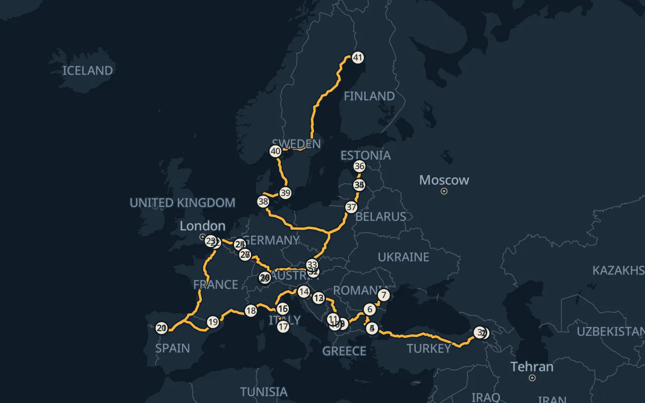
Drop the deadline and you get another question. How long does it take to visit all 41 countries on my list? The route goes from Armenia to Finland in about 163 h in the model. That includes the car train to and from the United Kingdom and a walk into Vatican City.
Compare the 3 routes on the map to see how much the route changes as you give it more time.
Plan the stops and crossings
The model uses posted speed limits where available. On its own 18-country attempt, Car and Driver reported going over the limit in France. Check border access and allow for inspections, traffic, fuel, and rest. Rotate rested drivers. RecordSetter rules.
The 41-country route budgets 15 minutes to park and walk into Vatican City and 80 minutes for each Channel crossing. For a real trip, check when LeShuttle needs you at the terminal. LeShuttle arrival guidance.
Which countries are on the list
The study counts 40 UN members plus Vatican City. It follows the road network from Europe through Turkey into the Caucasus, including Georgia and Armenia. The Channel Tunnel connects the United Kingdom to the route.
The study leaves out Ireland, Iceland, Malta, and Cyprus because they require a ferry. The road and border assumptions also leave out Belarus, Russia, Ukraine, Azerbaijan, and Kazakhstan. The 26- and 41-country routes pass through Kosovo, which is outside the study's UN-based count.
Every stop in order
The list shows how much road each route covers in each country.
18-country route
- 1Netherlands
- 2Belgium
- 3Luxembourg
- 4France
- 5Germany
- 6Switzerland
- 7Liechtenstein
- 8Austria
- 9Italy
- 10Slovenia
- 11Croatia
- 12Bosnia and Herzegovina
- 13Serbia
- 14Hungary
- 15Romania
- 16Czechia
- 17Slovakia
- 18Poland
26-country route
- 1Andorra
- 2France
- 3Spain
- 4Monaco
- 5Italy
- 6Liechtenstein
- 7Switzerland
- 8Austria
- 9Luxembourg
- 10Belgium
- 11Netherlands
- 12Germany
- 13Poland
- 14Czechia
- 15Slovakia
- 16Slovenia
- 17Hungary
- 18Bosnia and Herzegovina
- 19Croatia
- 20Romania
- 21Montenegro
- 22Serbia
- 23Albania
- 24North Macedonia
- 25Bulgaria
- 26Greece
41-country route
- 1Armenia
- 2Georgia
- 3Turkey
- 4Bulgaria
- 5Greece
- 6Romania
- 7Moldova
- 8Serbia
- 9North Macedonia
- 10Albania
- 11Montenegro
- 12Bosnia and Herzegovina
- 13Croatia
- 14Slovenia
- 15San Marino
- 16Italy
- 17Vatican City
- 18Monaco
- 19Andorra
- 20Portugal
- 21Spain
- 22France
- 23United Kingdom
- 24Netherlands
- 25Belgium
- 26Luxembourg
- 27Germany
- 28Switzerland
- 29Liechtenstein
- 30Austria
- 31Slovakia
- 32Hungary
- 33Czechia
- 34Lithuania
- 35Latvia
- 36Estonia
- 37Poland
- 38Denmark
- 39Sweden
- 40Norway
- 41Finland
Download the route and plan your run
The files follow the route on the map. Choose a route.
The GPX file is a simplified overview of the modeled route. The 41-country route includes 2 train crossings and a visit to Vatican City on foot. KML opens in Google Earth.
Google Maps and Apple Maps recalculate directions between stops. Each part starts where the last left off. Treat the map pins as route references and choose a legal place to pull over.
Have a route that might get to 19 countries in 24 hours? Send me your plan.
18-country route
- Part 1 Netherlands to GermanyGoogle MapsApple Maps
- Part 2 Germany to ItalyGoogle MapsApple Maps
- Part 3 Italy to SerbiaGoogle MapsApple Maps
- Part 4 Serbia to SlovakiaGoogle MapsApple Maps
- Part 5 Slovakia to PolandGoogle MapsApple Maps
26-country route
This route passes through Zubin Potok in northern Kosovo. The U.S. State Department advises against visiting that municipality. U.S. travel advisory for Kosovo.
- Part 1 Andorra to ItalyGoogle MapsApple Maps
- Part 2 Italy to LuxembourgGoogle MapsApple Maps
- Part 3 Luxembourg to PolandGoogle MapsApple Maps
- Part 4 Poland to HungaryGoogle MapsApple Maps
- Part 5 Hungary to MontenegroGoogle MapsApple Maps
- Part 6 Montenegro to BulgariaGoogle MapsApple Maps
- Part 7 Bulgaria to GreeceGoogle MapsApple Maps
41-country route
- Part 1 Armenia to GreeceGoogle MapsApple Maps
- Part 2 Greece to North MacedoniaGoogle MapsApple Maps
- Part 3 North Macedonia to CroatiaGoogle MapsApple Maps
- Part 4 Croatia to Terminal Gianicolo in RomeGoogle MapsApple Maps
- Part 5 Park at Terminal Gianicolo in Rome and walk to St. Peter's SquareCar parkVisitor access
- Part 6 Terminal Gianicolo in Rome to SpainGoogle MapsApple Maps
- Part 7 Spain to Coquelles passenger check-inGoogle MapsApple Maps
- Part 8 Coquelles to Folkestone by car trainLeShuttle check-in
- Part 9 Folkestone to Coquelles by car trainLeShuttle check-in
- Part 10 A16 after the Calais terminal to GermanyGoogle MapsApple Maps
- Part 11 Germany to SlovakiaGoogle MapsApple Maps
- Part 12 Slovakia to LatviaGoogle MapsApple Maps
- Part 13 Latvia to SwedenGoogle MapsApple Maps
- Part 14 Sweden to FinlandGoogle MapsApple Maps
Route files carry the OpenStreetMap attribution and ODbL notice.